
Image via Shutterstock.
Welcome back to Data Detective, where we walk step by step through public data to uncover what’s really happening in Illinois’ economic landscape.
This month, we’re turning our attention to Illinois’ logistics landscape—specifically, air cargo. The Midwest sits at the geographic heart of the United States, making it a natural hub for moving goods. Illinois is often described as a logistics leader, as the state is within a four-hour flight of anywhere in the continental U.S.
This raises a simple question:
How does Illinois’ air cargo activity actually compare to the rest of the Midwest?
To answer that, we’ll dig into publicly available data from the Federal Aviation Administration (FAA).
1. Find the Right FAA Data
Start at the FAA’s homepage. From the top navigation, select the Airports tab, then choose Planning & Capacity. Within that section, locate Passenger & All-Cargo Statistics, and select Passenger Boarding and All-Cargo Data.
Here, the FAA provides downloadable datasets covering passenger counts and cargo activity for U.S. airports. For this analysis, we’ll focus on All-Cargo Airports by Landed Weight, which measures the total weight of cargo aircraft landing at each airport over the course of a year.
For this example, we will be downloading the Calendar Year (CY) 2024 data in the .xlsx format.
2. Understand the Dataset
Once you open the file, you’ll see a national ranking of airports based on landed cargo weight, measured in pounds. Each row represents an airport, along with its state and total cargo weight for the year.
Right away, one thing stands out:
Illinois has two airports ranked among the top 15 cargo airports in the country.
That’s notable on its own, but rankings only tell part of the story. To understand Illinois’ position in the broader Midwest, we need to look at total cargo activity by state, not just individual airports.
3. Sum Cargo Weight by State
To calculate the total landed cargo weight for each Midwestern state, we can use a simple Excel function.
In a new column, list the Midwestern state abbreviations:
IL, IN, IA, KS, MI, MN, MO, NE, ND, OH, SD, and WI
This allows us to compare Illinois directly to its regional peers.
In the adjacent column, use the following formula: =SUMIF(D:D, [state cell], J:J)
In this formula:
- Column D contains state abbreviations
- Column J contains landed cargo weight
- The function sums all cargo weight values that match each state
This approach captures the combined cargo activity of all airports within each state, rather than focusing on individual facilities.
4. Examine the Data Further
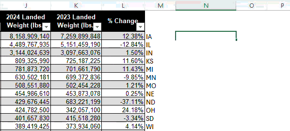
The results are striking! Illinois has the highest cumulative landed cargo weight among all Midwestern states at over 11.3 billion pounds in 2024.
For comparison, the second highest state, Indiana, recorded just under 4.8 billion pounds. For context, O’Hare alone handled roughly 8.1 billion pounds of landed cargo—more than the entire statewide total of any other Midwestern peer.
Illinois dominates the Midwest in air cargo activity by an order of magnitude.
Key Takeaway
By walking through a single, publicly available FAA dataset, we can see just how concentrated air cargo activity is in Illinois compared to its Midwestern neighbors. This kind of analysis is exactly what Data Detective is about: using public data to move beyond assumptions and into evidence.
For companies evaluating logistics operations in the Midwest, this data highlights a clear reality: Illinois operates at a different scale, and its infrastructure is considered world-class for a reason.
Get Curious
What data would you like our Research Team to tackle next? Let us know, and we’ll dive in.
Until next time!
RELATED POSTS